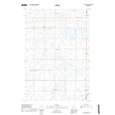
2018 Map of Coldwater Lake
USGS Topo · Published 2018About this map
Coldwater Lake dominates the southern landscape of this 2018 survey, situated within the distinct geography of the Coteau du Missouri. This region along the boundary of McIntosh and Dickey Counties is defined by its numerous small wetlands and glacial prairie potholes. The map reveals a high density of rural religious and burial sites, often associated with early German-Russian or Scandinavian settlement patterns in the Dakotas. Notable examples include the Zion II Lutheran (Biederstedt) Cemetery and the Zion Number 1 Evangelical Lutheran Cem, alongside smaller family or church plots like Bertsch Cem and the Cem of Salem. The section-line road network, including 94th St SE and 64th Ave SE, provides the framework for these scattered landmarks in a territory where the Unnamed Pioneer Cem suggests the deep roots of 19th-century homesteaders.
Find a feature on this map
27 named features on this map. Tap any name to fly to it.
Don’t see what you’re looking for? This feature index may not catch every label — zoom into the map to look around manually.
Map Details
Editions of this 2018 Coldwater Lake Map
This is the sole edition of this map. No revisions or reprints were ever made.
Other maps of this area

1896 · Edgeley
USGS Topo · 1:125,000

1899 · Ellendale
USGS Topo · 1:125,000

1925 · Edgeley
USGS Topo · 1:125,000

1953 · Jamestown
USGS Topo · 1:250,000

1954 · Aberdeen
USGS Topo · 1:250,000

1956 · Aberdeen
USGS Topo · 1:250,000

1956 · Jamestown
USGS Topo · 1:250,000

1968 · Long Lake NW
USGS Topo · 1:24,000

1968 · Long Lake NE
USGS Topo · 1:24,000
1968 · Forbes NW
USGS Topo · 1:24,000
Featured Places
- Spring Valley Township, ND
- German Township, ND
- Albertha Township, ND
- McIntosh County, ND
- Dickey County, ND