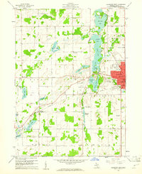
1960 Map of Coldwater West
USGS Topo · Published 1961About this map
Coldwater serves as the focal point for this 1960 survey, situated along the New York Central railroad corridor. The landscape is defined by a chain of glacial lakes, including Morrison Lake, Randall Lake, Cemetery Lake, and Messenger Lake, which helped shape the city's western development and provided a backdrop for the Branch County Memorial Airport. To the west, the townships of Union, Batavia, and Bethel maintain a rural character, marked by country schools such as Centennial Sch and Maple Grove Sch. One distinctive historical element is the Old Indian Bdy line cutting across the northeast, a vestige of early land treaties that continues to influence the platting of Girard and Coldwater townships. Further south, the Coldwater River feeds into the Blackhawk Millpond, a site of early local industry.
Find a feature on this map
57 named features on this map. Tap any name to fly to it.
Don’t see what you’re looking for? This feature index may not catch every label — zoom into the map to look around manually.
Map Details
Editions of this 1960 Coldwater West Map
2 editions found
Other maps of this area

1918 · Union City
USGS Topo · 1:62,500

1947 · Union City
USGS Topo · 1:62,500

1948 · Homer
USGS Topo · 1:62,500

1949 · Homer
USGS Topo · 1:62,500

1950 · Union City
USGS Topo · 1:62,500

1953 · Fort Wayne
USGS Topo · 1:250,000

1956 · Fort Wayne
USGS Topo · 1:250,000

1958 · Grand Rapids
USGS Topo · 1:250,000

1960 · Coldwater West
USGS Topo · 1:24,000

1960 · Coldwater East
USGS Topo · 1:24,000