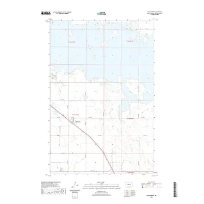
2020 Map of Coleharbor
USGS Topo · Published 2020About this map
Coleharbor sits at the heart of this McLean County landscape, defined by the intricate shoreline of Audubon Lake to the north and east. The settlement is anchored by local infrastructure, including a Po and the Coleharbor Cem located to the south. This modern survey illustrates a rural environment shaped by the intersection of traditional section lines and major water bodies, with the winding course of Wolf Cr cutting through the western terrain. The presence of the Prairie Trail and a well-defined grid of township roads, such as 14th ST NW and Co Hwy 12, reveals a landscape managed for both agriculture and conservation. The proximity to the lake suggests a region where the natural geography of the Missouri River basin and modern water management dictate the pattern of human habitation and transportation.
Find a feature on this map
20 named features on this map. Tap any name to fly to it.
Don’t see what you’re looking for? This feature index may not catch every label — zoom into the map to look around manually.
Map Details
Editions of this 2020 Coleharbor Map
This is the sole edition of this map. No revisions or reprints were ever made.
Other maps of this area

1922 · Garrison
USGS Topo · 1:62,500

1929 · Coleharbor
USGS Topo · 1:62,500

1948 · Stanton
USGS Topo · 1:62,500

1949 · Stanton
USGS Topo · 1:62,500

1949 · Washburn
USGS Topo · 1:62,500

1954 · McClusky
USGS Topo · 1:250,000

1958 · McClusky
USGS Topo · 1:250,000

1961 · Lake Nettie
USGS Topo · 1:24,000

1961 · Washburn NE
USGS Topo · 1:24,000

1961 · Underwood
USGS Topo · 1:24,000