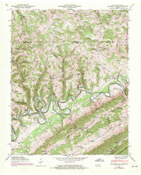
1946 Map of Colemen Gap
USGS Topo · Published 1970About this map
The Powell River carves a dramatic, winding path through the borderlands of Tennessee and Virginia, defining the character of this mid-century landscape. The river’s tight loops at Rowland Bend and Elk Bend necessitated local infrastructure like Brooks Ferry and Brooks Bridge for travelers navigating the valleys between Brooks Ridge and Newman Ridge. This terrain supported a network of small upland communities centered around local institutions such as Chestnut Grove Church, Smith Chapel, and Yeary Sch.
Find a feature on this map
99 named features on this map. Tap any name to fly to it.
Don’t see what you’re looking for? This feature index may not catch every label — zoom into the map to look around manually.
Map Details
Editions of this 1946 Colemen Gap Map
This is the sole edition of this map. No revisions or reprints were ever made.
Other maps of this area

1883 · Morristown
USGS Topo · 1:125,000

1886 · Cumberland Gap
USGS Topo · 1:125,000

1887 · Jonesville
USGS Topo · 1:125,000

1888 · Cumberland Gap
USGS Topo · 1:125,000

1891 · Cumberland Gap
USGS Topo · 1:125,000

1891 · Jonesville
USGS Topo · 1:125,000

1893 · Morristown
USGS Topo · 1:125,000

1895 · Morristown
USGS Topo · 1:125,000

1897 · Maynardville
USGS Topo · 1:125,000

1900 · Maynardville
USGS Topo · 1:125,000