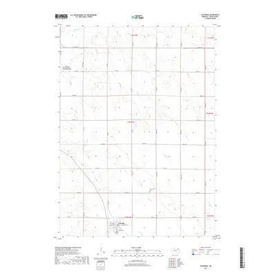
2017 Map of Coleridge
USGS Topo · Published 2017About this map
Coleridge serves as the primary hub in this portion of Cedar County, situated at the intersection of a grid-iron road network including W Broadway St and 567th Ave. The surrounding landscape is defined by the dissection of the loess plains by numerous small waterways, most notably Bow Creek, Dead Cr, and Kerloo Cr. These drainage patterns influenced the early settlement and placement of rural landmarks, visible in the distribution of community sites across the townships.
Find a feature on this map
36 named features on this map. Tap any name to fly to it.
Don’t see what you’re looking for? This feature index may not catch every label — zoom into the map to look around manually.
Map Details
Editions of this 2017 Coleridge Map
This is the sole edition of this map. No revisions or reprints were ever made.
Other maps of this area

1955 · Sioux City
USGS Topo · 1:250,000

1958 · Sioux City
USGS Topo · 1:250,000

1959 · Sioux City
USGS Topo · 1:250,000

1968 · Obert
USGS Topo · 1:24,000

1968 · Coleridge
USGS Topo · 1:24,000

1968 · Hartington
USGS Topo · 1:24,000

1968 · Wynot
USGS Topo · 1:24,000
1968 · Coleridge SE
USGS Topo · 1:24,000

1968 · Fordyce
USGS Topo · 1:24,000
1971 · Laurel
USGS Topo · 1:24,000