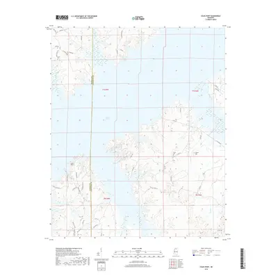
2018 Map of Coles Point
USGS Topo · Published 2018About this map
Sardis Lake dominates this landscape, its irregular shoreline creating a complex network of coves and points along the Panola and Lafayette county line. The map captures a mix of established rural settlements and newer recreational residential development. Older sites like the community of Emery and the Emery Cem stand near the northern reaches, while the eastern terrain rises toward Carter Mtn. Local family and place names are preserved in the road network, including Pats Bluff Rd, Riales Rd, and Lafferty Rd. The transition between the high ground and the sprawling reservoir is marked by smaller drainages such as Plants Br and Buford Cr, illustrating the hydrological transformation of this Mississippi region following the damming of the Tallahatchie River.
Find a feature on this map
45 named features on this map. Tap any name to fly to it.
Don’t see what you’re looking for? This feature index may not catch every label — zoom into the map to look around manually.
Map Details
Editions of this 2018 Coles Point Map
This is the sole edition of this map. No revisions or reprints were ever made.
Other maps of this area

1940 · Oxford
USGS Topo · 1:62,500

1943 · Oxford
USGS Topo · 1:62,500

1944 · Senatobia
USGS Topo · 1:62,500

1944 · Tyro
USGS Topo · 1:62,500

1952 · Sardis
USGS Topo · 1:62,500

1953 · Sardis
USGS Topo · 1:62,500

1956 · Tupelo
USGS Topo · 1:250,000

1958 · Tupelo
USGS Topo · 1:250,000

1971 · Laws Hill
USGS Topo · 1:24,000
1971 · Tyro
USGS Topo · 1:24,000