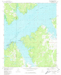
1980 Map of Coles Point
USGS Topo · Published 1981About this map
Sardis Lake dominates this 1980 survey, where the waters of the Little Tallahatchie River spread across the borders of Panola and Lafayette counties. The map reflects a landscape transformed for mid-century recreation and flood control, featuring several recreational hubs such as Pats Bluff and the Coles Point Public Use Area. Despite the inundation of the river valley, remnants of the older upland settlement patterns persist on the surrounding heights. Researchers will find rural landmarks like Carter Mountain and local spiritual centers including Galilee Ch and Spring Hill Ch. The presence of the Emery Cem and Elijah Cem offers specific points of interest for genealogists tracing families in this part of Mississippi before and after the reservoir's creation. Smaller tributaries like Greasy Creek and Plants Branch continue to feed the expansive lake from the wooded hillsides.
Find a feature on this map
21 named features on this map. Tap any name to fly to it.
Don’t see what you’re looking for? This feature index may not catch every label — zoom into the map to look around manually.
Map Details
Editions of this 1980 Coles Point Map
This is the sole edition of this map. No revisions or reprints were ever made.
Other maps of this area

1940 · Oxford
USGS Topo · 1:62,500

1943 · Oxford
USGS Topo · 1:62,500

1944 · Senatobia
USGS Topo · 1:62,500

1944 · Tyro
USGS Topo · 1:62,500

1952 · Sardis
USGS Topo · 1:62,500

1953 · Sardis
USGS Topo · 1:62,500

1956 · Tupelo
USGS Topo · 1:250,000

1958 · Tupelo
USGS Topo · 1:250,000

1971 · Laws Hill
USGS Topo · 1:24,000
1971 · Tyro
USGS Topo · 1:24,000