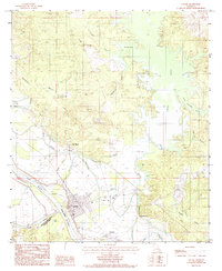
1985 Map of Colfax
USGS Topo · Published 1985About this map
The parish seat of Colfax anchors the banks of the Red River in this mid-1980s landscape, where the alluvial plain meets the complex bayou networks of central Louisiana. The terrain is defined by the expansive Iatt Lake to the east and the meandering courses of Rigolette Bayou and Grappe Bayou. Local history is visible in the smaller settlements and geographic markers such as Summerfield, Mc Neely, and the aptly named The Rock. The area's hydrology is particularly intricate, featuring numerous named branches like Three Branches Creek and Cholera Branch, alongside oxbow remnants like Flag Lake. This survey captures the region's intersection of water and land, showing a community structured by its riverine geography and agricultural boundaries including the meeting point of Natchitoches, Rapides, and Grant Parishes.
Find a feature on this map
34 named features on this map. Tap any name to fly to it.
Don’t see what you’re looking for? This feature index may not catch every label — zoom into the map to look around manually.
Map Details
Editions of this 1985 Colfax Map
2 editions found
Other maps of this area

1932 · Colfax NE
USGS Topo · 1:31,680

1932 · Boyce NE
USGS Topo · 1:31,680

1932 · Colfax SW
USGS Topo · 1:31,680

1932 · Colfax SE
USGS Topo · 1:31,680

1932 · Colfax NW
USGS Topo · 1:31,680

1935 · Verda
USGS Topo · 1:31,680

1936 · Colfax
USGS Topo · 1:62,500

1937 · Chopin NE
USGS Topo · 1:31,680

1937 · Aloha
USGS Topo · 1:31,680

1937 · Montgomery
USGS Topo · 1:62,500