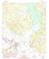
1985 Map of Colfax
USGS Topo · Published 1993About this map
Colfax serves as the focal point of this 1980s landscape, situated at the confluence of the Red River and the complex wetlands of Grant Parish. The map illustrates a transition from the structured street grid of the town to the hydraulic engineering of the Levee system and the Spillway controlling the sprawling waters of Iatt Lake. This era shows the local economic reliance on the river and earthworks, evidenced by the large Sand and Gravel Pit operations and the Sewage Disposal Plant nearby. Rural life is anchored by small settlements like Summerfield and The Rock, with a quiet landscape of cemeteries and named bayous such as Sugarhouse Bayou and Valentine Bayou. The intersection of parish lines, including Natchitoches Parish and Rapides Parish, highlights the administrative boundaries that have historically defined these Central Louisiana river communities.
Find a feature on this map
31 named features on this map. Tap any name to fly to it.
Don’t see what you’re looking for? This feature index may not catch every label — zoom into the map to look around manually.
Map Details
Editions of this 1985 Colfax Map
2 editions found
Other maps of this area

1932 · Colfax NE
USGS Topo · 1:31,680

1932 · Boyce NE
USGS Topo · 1:31,680

1932 · Colfax SW
USGS Topo · 1:31,680

1932 · Colfax SE
USGS Topo · 1:31,680

1932 · Colfax NW
USGS Topo · 1:31,680

1935 · Verda
USGS Topo · 1:31,680

1936 · Colfax
USGS Topo · 1:62,500

1937 · Chopin NE
USGS Topo · 1:31,680

1937 · Aloha
USGS Topo · 1:31,680

1937 · Montgomery
USGS Topo · 1:62,500