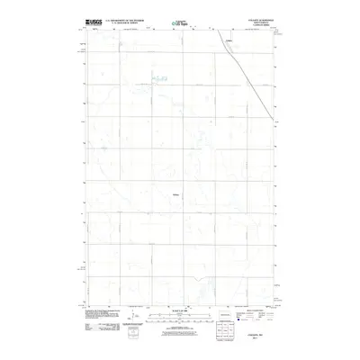
2011 Map of Colgate
USGS Topo · Published 2011About this map
Colgate and Walden anchor this 2011 survey of Steele County, revealing a landscape defined by the rigid grid of the Public Land Survey System. The map traces the rectilinear network of rural roads, including County Hwy-1 and County Hwy-6, which section the agricultural terrain into precise squares. A prominent diagonal transportation corridor cuts through the northern portion of the map, passing directly through Colgate and providing a stark contrast to the surrounding north-south and east-west thoroughfares like 130th Ave SE and 18th St SE. Numerous small wetlands and depressions are scattered across the township, particularly between 131st Ave SE and 133rd Ave SE, reflecting the post-glacial topography typical of this region of North Dakota.
Find a feature on this map
17 named features on this map. Tap any name to fly to it.
Don’t see what you’re looking for? This feature index may not catch every label — zoom into the map to look around manually.
Map Details
Editions of this 2011 Colgate Map
This is the sole edition of this map. No revisions or reprints were ever made.
Other maps of this area

1952 · Grand Forks
USGS Topo · 1:250,000

1956 · Grand Forks
USGS Topo · 1:250,000

1966 · Grand Forks
USGS Topo · 1:250,000

1966 · Hope SE
USGS Topo · 1:24,000

1967 · Pillsbury SE
USGS Topo · 1:24,000

1967 · Page SE
USGS Topo · 1:24,000

1967 · Page
USGS Topo · 1:24,000
1967 · Pillsbury
USGS Topo · 1:24,000
1967 · Page SW
USGS Topo · 1:24,000

1967 · Colgate
USGS Topo · 1:24,000
Featured Places
- Colgate Township, ND
- Carpenter Township, ND
- Minnie Lake Township, ND
- Ellsbury Township, ND
- Rochester Township, ND