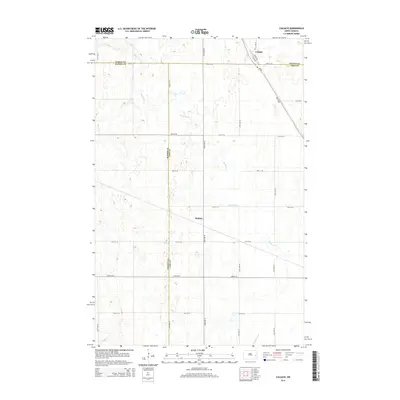
2014 Map of Colgate
USGS Topo · Published 2014About this map
The Maple River meanders across this rural landscape, carving a winding path through the prairie terrain of eastern North Dakota. This section of the Red River Valley hinterlands is defined by a rigid section-line grid of gravel roads and the diagonal transit corridor of ND-38. The small settlement of Colgate serves as a primary point of reference in the northeast, where Main Ave and Front Ave meet the highway. Further south, the map identifies Walden, a location situated along the secondary road network. The geography here is marked by the complex intersection of county lines, where Steele Co, Barnes Co, and Cass Co converge. This survey offers a clear view of modern agricultural land division and the persistent small-town footprints that characterize the region's contemporary rural structure.
Find a feature on this map
25 named features on this map. Tap any name to fly to it.
Don’t see what you’re looking for? This feature index may not catch every label — zoom into the map to look around manually.
Map Details
Editions of this 2014 Colgate Map
This is the sole edition of this map. No revisions or reprints were ever made.
Other maps of this area

1952 · Grand Forks
USGS Topo · 1:250,000

1956 · Grand Forks
USGS Topo · 1:250,000

1966 · Grand Forks
USGS Topo · 1:250,000

1966 · Hope SE
USGS Topo · 1:24,000

1967 · Pillsbury SE
USGS Topo · 1:24,000

1967 · Page SE
USGS Topo · 1:24,000

1967 · Page
USGS Topo · 1:24,000
1967 · Pillsbury
USGS Topo · 1:24,000
1967 · Page SW
USGS Topo · 1:24,000

1967 · Colgate
USGS Topo · 1:24,000
Featured Places
- Colgate Township, ND
- Carpenter Township, ND
- Minnie Lake Township, ND
- Ellsbury Township, ND
- Rochester Township, ND