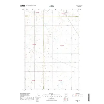
2018 Map of Colgate
USGS Topo · Published 2018About this map
Colgate and the small settlement of Walden anchor this 2018 survey of eastern North Dakota, situated at the intersection of Steele, Barnes, and Cass Counties. The landscape is defined by the winding course of the Maple River, which meanders southeastward across a grid of section lines and gravel roads. This area reflects the late-period rural character of the Red River Valley hinterlands, where the township boundaries of T144N, T143N, and T142N meet. Local transportation relies on a network of established corridors including Co Hwy 1, Co Hwy 6, and Co Rd 26. The map captures the agricultural spatial organization of the region, where isolated farmsteads are linked by named thoroughfares like Trevor Dr and Main Ave. For those researching local land use or family history in this tri-county corner, the survey provides precise positioning of modern infrastructure relative to the ancient watercourse of the river.
Find a feature on this map
29 named features on this map. Tap any name to fly to it.
Don’t see what you’re looking for? This feature index may not catch every label — zoom into the map to look around manually.
Map Details
Editions of this 2018 Colgate Map
This is the sole edition of this map. No revisions or reprints were ever made.
Other maps of this area

1952 · Grand Forks
USGS Topo · 1:250,000

1956 · Grand Forks
USGS Topo · 1:250,000

1966 · Grand Forks
USGS Topo · 1:250,000

1966 · Hope SE
USGS Topo · 1:24,000

1967 · Pillsbury SE
USGS Topo · 1:24,000

1967 · Page SE
USGS Topo · 1:24,000

1967 · Page
USGS Topo · 1:24,000
1967 · Pillsbury
USGS Topo · 1:24,000
1967 · Page SW
USGS Topo · 1:24,000

1967 · Colgate
USGS Topo · 1:24,000
Featured Places
- Colgate Township, ND
- Carpenter Township, ND
- Minnie Lake Township, ND
- Ellsbury Township, ND
- Rochester Township, ND