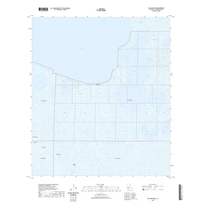
2020 Map of Collicon Lake
USGS Topo · Published 2020About this map
Collicon Lake and the vast marshes of Cameron Parish define this coastal landscape, where the land and water are inextricably linked through a complex system of natural bayous and man-made canals. In the northeastern portion of the quadrangle, the Blackfish Canal and Round Lake Canal illustrate early water management and navigation efforts near Blackfish Bay. The southern half of the map is dominated by expansive wetlands interspersed with named high points such as Eagle Island, High Island, and Twin Island, which likely served as critical refuges in this low-lying terrain. The transition from large open water bodies like Grand Lake to smaller, locally named basins like Petit Lac L'Huit and Grand Lac L'Huit reflects the intricate hydrology of the region. This 2020 survey documents the modern extent of these coastal features, from Lake Benoit in the west to the winding course of Coon Mound Bayou in the east.
Find a feature on this map
27 named features on this map. Tap any name to fly to it.
Don’t see what you’re looking for? This feature index may not catch every label — zoom into the map to look around manually.
Map Details
Editions of this 2020 Collicon Lake Map
This is the sole edition of this map. No revisions or reprints were ever made.
Other maps of this area

1932 · Constance Bayou NE
USGS Topo · 1:31,680

1932 · Constance Bayou NW
USGS Topo · 1:31,680

1934 · Catfish Lake
USGS Topo · 1:24,000

1934 · Latania Lake
USGS Topo · 1:24,000

1935 · Catfish Lake
USGS Topo · 1:31,680

1935 · Latania Lake
USGS Topo · 1:31,680

1946 · Hog Bayou NE
USGS Topo · 1:31,680

1949 · Hog Bayou NE
USGS Topo · 1:31,680

1954 · Grand Lake East NW
USGS Topo · 1:31,680

1954 · Grand Lake East SE
USGS Topo · 1:31,680