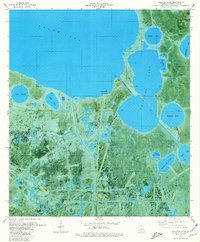
1979 Map of Collicon Lake
USGS Topo · Published 1980About this map
Cheniere du Fond stands as a primary point of human activity within this 1970s orthophotomap of the Louisiana marshlands. The landscape is defined by an intricate network of natural and engineered waterways, including the Grand Lake shoreline and the Old Intracoastal Waterway. Industrial footprints are deeply integrated into the terrain, evidenced by the Pecan Lake Gas Field and the South Pecan Lake Oil and Gas Field, which are marked by access roads and sludge pits carved into the wetlands. Named features like Eagle Island, High Island, and the Little Islands highlight the subtle elevation changes that dictate survival in this amphibious environment. Geographers and local historians can trace the intersection of coastal ecology and energy extraction through features like Blackfish Bayou and the man-made Round Lake Canal during a period of significant wetland development.
Find a feature on this map
35 named features on this map. Tap any name to fly to it.
Don’t see what you’re looking for? This feature index may not catch every label — zoom into the map to look around manually.
Map Details
Editions of this 1979 Collicon Lake Map
This is the sole edition of this map. No revisions or reprints were ever made.
Other maps of this area

1932 · Constance Bayou NE
USGS Topo · 1:31,680

1932 · Constance Bayou NW
USGS Topo · 1:31,680

1934 · Catfish Lake
USGS Topo · 1:24,000

1934 · Latania Lake
USGS Topo · 1:24,000

1935 · Catfish Lake
USGS Topo · 1:31,680

1935 · Latania Lake
USGS Topo · 1:31,680

1946 · Hog Bayou NE
USGS Topo · 1:31,680

1949 · Hog Bayou NE
USGS Topo · 1:31,680

1954 · Grand Lake East NW
USGS Topo · 1:31,680

1954 · Grand Lake East SE
USGS Topo · 1:31,680