
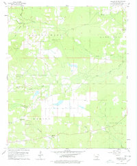
1960 Map of Collins NW
USGS Topo · Published 1961About this map
Small country churches and family burial grounds dot this corner of Drew County at the start of the 1960s. The landscape is defined by the headwaters and branches of Upper Cutoff Creek, Godfrey Creek, and Hurricane Creek, which carve through the townships of Marion and Franklin. The map reveals a dispersed rural society centered on places of worship such as Jose Chapel, Mt Zion Ch, and Old Union Ch.
Find a feature on this map
22 named features on this map. Tap any name to fly to it.
Don’t see what you’re looking for? This feature index may not catch every label — zoom into the map to look around manually.
Map Details
Editions of this 1960 Collins NW Map
2 editions found
Other maps of this area

1935 · Feenyville
USGS Topo · 1:62,500

1935 · Cominto
USGS Topo · 1:62,500

1935 · Rotan
USGS Topo · 1:62,500

1953 · Greenwood
USGS Topo · 1:250,000

1956 · Greenwood
USGS Topo · 1:250,000

1960 · Selma
USGS Topo · 1:24,000

1960 · Collins
USGS Topo · 1:24,000

1960 · Collins
USGS Topo · 1:62,500

1960 · Cominto
USGS Topo · 1:24,000
1964 · Gourd
USGS Topo · 1:24,000