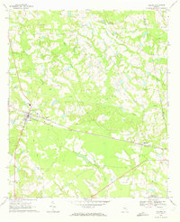
1970 Map of Collins
USGS Topo · Published 1973About this map
Collins and Manassas serve as the primary hubs of activity in this Tattnall County landscape, connected by the steady line of the Seaboard Coast Line railroad. The map documents a rural Georgia community defined by its numerous family and church burial grounds, including Rodgers Ch Cem, Wilkinson Cem, and the Tippins Cem. These sites, along with localized congregations like Mt Pilgrim Ch and Bethaven Ch, anchor the social fabric of the area.
Find a feature on this map
32 named features on this map. Tap any name to fly to it.
Don’t see what you’re looking for? This feature index may not catch every label — zoom into the map to look around manually.
Map Details
Editions of this 1970 Collins Map
This is the sole edition of this map. No revisions or reprints were ever made.
Other maps of this area

1919 · Claxton
USGS Topo · 1:62,500

1920 · Statesboro
USGS Topo · 1:62,500

1943 · Statesboro
USGS Topo · 1:62,500

1944 · Claxton
USGS Topo · 1:62,500

1947 · Savannah
USGS Topo · 1:250,000

1948 · Savannah
USGS Topo · 1:250,000

1950 · Claxton
USGS Topo · 1:62,500

1957 · Macon
USGS Topo · 1:250,000

1957 · Savannah
USGS Topo · 1:250,000

1958 · Macon
USGS Topo · 1:250,000