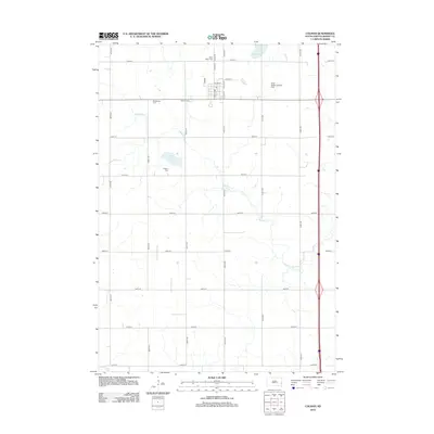
2012 Map of Colman
USGS Topo · Published 2012About this map
Colman serves as the central hub of this agricultural landscape in Moody County, organized around a rigid grid of section-line roads such as 470th Ave and 238th St. The town center contains the local Po and is situated just south of the Sioux Valley Landing Strip. This 2012 survey illustrates a region where local heritage is preserved in numerous rural burial grounds, including Saint Peters Cem, Molskness Cem, Colman Cem, and Hegrey Cem, many of which sit adjacent to family-named roads.
Find a feature on this map
31 named features on this map. Tap any name to fly to it.
Don’t see what you’re looking for? This feature index may not catch every label — zoom into the map to look around manually.
Map Details
Editions of this 2012 Colman Map
This is the sole edition of this map. No revisions or reprints were ever made.
Other maps of this area

1953 · Watertown
USGS Topo · 1:250,000

1955 · Sioux Falls
USGS Topo · 1:250,000

1958 · Sioux Falls
USGS Topo · 1:250,000
1958 · Watertown
USGS Topo · 1:250,000
1962 · Colton SE
USGS Topo · 1:24,000
1962 · Dell Rapids
USGS Topo · 1:24,000
1963 · Trent
USGS Topo · 1:24,000
1963 · Colman
USGS Topo · 1:24,000
1964 · Rutland SE
USGS Topo · 1:24,000
1964 · Flandreau SW
USGS Topo · 1:24,000