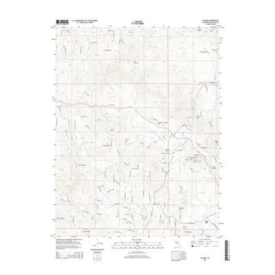
2015 Map of Coloma
USGS Topo · Published 2015About this map
Coloma and the nearby settlement of Lotus sit along a bend of the South Fork American River, a landscape defined by its deep connection to the California Gold Rush. This survey captures a dense concentration of local history markers, including the Marshall Gravesite, Pioneer Cemetery, and Uniontown Cemetery. The topography transitions from the river valley to prominent peaks such as Mt Ararat and Perry Mtn, while small airstrips like Bacchi Valley Industries Airport and Akin Airport highlight the modern rural infrastructure. To the south, the community of Gold Hill is situated near Weber Cr, with a network of local roads such as Gold Hill Rd and Cold Springs Rd connecting the dispersed residential and agricultural tracts. This era shows the developed road network over terrain historically shaped by mining and early settlement.
Find a feature on this map
128 named features on this map. Tap any name to fly to it.
Don’t see what you’re looking for? This feature index may not catch every label — zoom into the map to look around manually.
Map Details
Editions of this 2015 Coloma Map
This is the sole edition of this map. No revisions or reprints were ever made.
Other maps of this area

1891 · Sacramento
USGS Topo · 1:125,000

1891 · Placerville
USGS Topo · 1:125,000

1892 · Sacramento
USGS Topo · 1:125,000

1892 · Placerville
USGS Topo · 1:125,000

1893 · Placerville
USGS Topo · 1:125,000

1893 · Sacramento
USGS Topo · 1:125,000

1941 · Folsom
USGS Topo · 1:62,500
1944 · Auburn
USGS Topo · 1:62,500
1944 · Folsom
USGS Topo · 1:62,500

1947 · Sacramento
USGS Topo · 1:250,000