
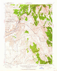
1941 Map of Folsom
USGS Topo · Published 1957About this map
The American River, also labeled here as the Rio de los Americanos, dominates this early 1940s landscape just before the construction of massive local dams transformed the river valley. The settlement of Folsom and its neighboring State Prison Represa sit at the center of a transition from the agricultural plains of Orangevale and San Juan to the rising foothills of the Sierra Nevada. This map documents a period when the river still flowed through historic gold-rush locations like Mississippi Bar, Nigger Bar, and Sailor Bar before they were altered by mid-century water projects.
Find a feature on this map
50 named features on this map. Tap any name to fly to it.
Don’t see what you’re looking for? This feature index may not catch every label — zoom into the map to look around manually.
Map Details
Editions of this 1941 Folsom Map
2 editions found
Other maps of this area

1889 · Jackson
USGS Topo · 1:125,000

1891 · Sacramento
USGS Topo · 1:125,000

1891 · Placerville
USGS Topo · 1:125,000

1892 · Jackson
USGS Topo · 1:125,000

1892 · Sacramento
USGS Topo · 1:125,000

1892 · Placerville
USGS Topo · 1:125,000

1893 · Placerville
USGS Topo · 1:125,000

1893 · Sacramento
USGS Topo · 1:125,000

1894 · Lodi
USGS Topo · 1:125,000

1897 · Jackson
USGS Topo · 1:125,000