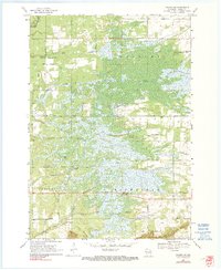
1968 Map of Coloma SW
USGS Topo · Published 1990About this map
Big Flats and the surrounding townships of Colburn, Preston, and Richfield reveal a landscape defined by an intricate network of wetlands and seasonal drainages in Adams County. Water is the primary architect here, with the northern reaches marked by Big Roche a Cri Creek and the southern portion drained by Little Roche a Cri Creek. The area's hydrology is further detailed by features like Carter Creek, Bingham Creek, and Dry Creek. Cultural markers are sparse but significant, including Ship Rock Wayside Park along a major thoroughfare. The map's grid of section lines and early rural roads, such as Brown Deer Avenue and Chicago Avenue, shows the systematic parceling of this marshy terrain during the mid-20th century, providing a clear view of the land before modern intensive development.
Find a feature on this map
31 named features on this map. Tap any name to fly to it.
Don’t see what you’re looking for? This feature index may not catch every label — zoom into the map to look around manually.
Map Details
Editions of this 1968 Coloma SW Map
2 editions found

Other maps of this area

1955 · Green Bay
USGS Topo · 1:250,000

1957 · Madison
USGS Topo · 1:250,000

1958 · Arkdale
USGS Topo · 1:48,000

1958 · Coloma
USGS Topo · 1:48,000

1960 · Madison
USGS Topo · 1:250,000

1961 · Oxford
USGS Topo · 1:62,500

1961 · Adams
USGS Topo · 1:62,500

1967 · Roche A Cri
USGS Topo · 1:24,000

1967 · Arkdale NE
USGS Topo · 1:24,000

1968 · Coloma NW
USGS Topo · 1:24,000