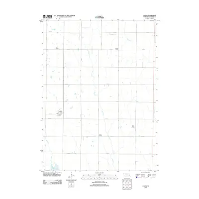
2011 Map of Colon
USGS Topo · Published 2011About this map
Colon serves as the central hub of this agricultural landscape in Saunders County, Nebraska, where the village layout is anchored by the Colon Post Office. The surrounding terrain is defined by a grid of rural roads, including Colon Rd and several numbered county routes, which facilitate access to the expansive farmsteads between the creek systems. The hydrology is dominated by the winding course of Silver Creek through the center of the sheet, while the southern boundary is marked by the presence of Lake Wanahoo and Sand Creek. For local historians and genealogists, the map preserves the exact locations of several vital community landmarks, specifically the Union Cemetery, Platteville Cemetery, Marietta Cemetery, and Green Mound Cemetery. These sites, spaced across the countryside near waterways like Otoe Creek and Upper Clear Creek, reflect the distribution of early settlements and the long-standing family ties to this portion of the Nebraska plains.
Find a feature on this map
25 named features on this map. Tap any name to fly to it.
Don’t see what you’re looking for? This feature index may not catch every label — zoom into the map to look around manually.
Map Details
Editions of this 2011 Colon Map
This is the sole edition of this map. No revisions or reprints were ever made.
Other maps of this area

1893 · Fremont
USGS Topo · 1:125,000

1896 · Fremont
USGS Topo · 1:125,000

1899 · Wahoo
USGS Topo · 1:125,000

1955 · Fremont
USGS Topo · 1:250,000

1957 · Fremont
USGS Topo · 1:250,000

1958 · Fremont
USGS Topo · 1:250,000

1968 · Leshara
USGS Topo · 1:24,000
1968 · Malmo NW
USGS Topo · 1:24,000
1968 · Fremont West
USGS Topo · 1:24,000

1968 · Fremont East
USGS Topo · 1:24,000