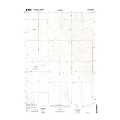
2014 Map of Colon
USGS Topo · Published 2014About this map
Colon serves as the central hub for this Saunders County landscape, appearing here in the early 21st century as a quiet crossroads community. The village is surrounded by a strictly organized grid of rural roads, including Colon Rd and numerous numeric and lettered routes like Co Road 16 and Co Road Q. The map reveals a deeply rooted rural heritage through its distribution of community burial grounds, such as Union Cem to the northwest and Platteville Cem to the northeast. Several watercourses, including Silver Cr and Otoe Cr, cut through the geometric survey lines, while Marietta Cem and Green Mound Cem provide further evidence of early settlement patterns in this agricultural heartland.
Find a feature on this map
25 named features on this map. Tap any name to fly to it.
Don’t see what you’re looking for? This feature index may not catch every label — zoom into the map to look around manually.
Map Details
Editions of this 2014 Colon Map
This is the sole edition of this map. No revisions or reprints were ever made.
Other maps of this area

1893 · Fremont
USGS Topo · 1:125,000

1896 · Fremont
USGS Topo · 1:125,000

1899 · Wahoo
USGS Topo · 1:125,000

1955 · Fremont
USGS Topo · 1:250,000

1957 · Fremont
USGS Topo · 1:250,000

1958 · Fremont
USGS Topo · 1:250,000

1968 · Leshara
USGS Topo · 1:24,000
1968 · Malmo NW
USGS Topo · 1:24,000
1968 · Fremont West
USGS Topo · 1:24,000

1968 · Fremont East
USGS Topo · 1:24,000