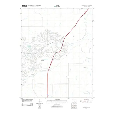
2010 Map of Colorado City
USGS Topo · Published 2010About this map
Colorado City and the neighboring settlement of Greenhorn anchor this 2010 survey of south-central Colorado. The landscape is defined by its complex drainage network, where the waters of Greenhorn Creek and Graneros Creek meet the arid terrain of the Graneros Gorge. Local infrastructure is highly visible, featuring the Beckwith Reservoir and Bonnie Meade Reservoir, both essential water management points for this high-plains community. A unique industrial footprint is found at the Cedarwood Clay Mine to the east, illustrating the region's mineral extraction history. Aviation and transport are represented by the Greenhorn Valley Airport, which sits north of the main residential clusters. The map details a transition from the structured street grids of the planned community to the natural arroyos and springs, such as Walters Spring and Mustang Arroyo, that carve through the surrounding prairie.
Find a feature on this map
18 named features on this map. Tap any name to fly to it.
Don’t see what you’re looking for? This feature index may not catch every label — zoom into the map to look around manually.
Map Details
Editions of this 2010 Colorado City Map
This is the sole edition of this map. No revisions or reprints were ever made.
Other maps of this area

1891 · Walsenburg
USGS Topo · 1:125,000

1891 · Pueblo
USGS Topo · 1:125,000

1894 · Walsenburg
USGS Topo · 1:125,000

1894 · Pueblo
USGS Topo · 1:125,000

1896 · Pueblo
USGS Topo · 1:125,000

1897 · Pueblo
USGS Topo · 1:125,000

1897 · Walsenburg
USGS Topo · 1:125,000

1900 · Walsenburg
USGS Topo · 1:125,000

1954 · Trinidad
USGS Topo · 1:250,000

1954 · Pueblo
USGS Topo · 1:250,000