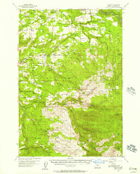
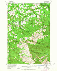
1955 Map of Colton
USGS Topo · Published 1957This historical map portrays the area of Colton in 1955, primarily covering Clackamas County. Featuring a scale of 1:62500, this map provides a highly detailed snapshot of the terrain, roads, buildings, counties, and historical landmarks in the Colton region at the time. Published in 1957, it is one of 3 known editions of this map due to revisions or reprints.
Find a feature on this map
76 named features on this map. Tap any name to fly to it.
Don’t see what you’re looking for? This feature index may not catch every label — zoom into the map to look around manually.
Map Details
Editions of this 1955 Colton Map
3 editions found
Historical Maps of Old Colton Through Time
53 maps found

1954 Redland
Clackamas County, OR

1955 Cherryville
Clackamas County, OR

1955 Colton
Clackamas County, OR

1955 Colton
Clackamas County, OR

1955 Wilhoit
Clackamas County, OR

1955 Yoder
Clackamas County, OR

1956 Fish Creek Mtn
Clackamas County, OR

1956 High Rock
Clackamas County, OR

1961 Redland
Clackamas County, OR

1962 Bull Run Lake
Clackamas County, OR

1962 Hickman Butte
Clackamas County, OR

1985 Bagby Hot Springs
Clackamas County, OR

1985 Bull of The Woods
Clackamas County, OR

1985 Bull Run
Clackamas County, OR

1985 Cherryville
Clackamas County, OR

1985 Fish Creek Mountain
Clackamas County, OR

1985 High Rock
Clackamas County, OR

1985 Mt. Mitchell
Clackamas County, OR

1985 Rooster Rock
Clackamas County, OR

1985 Three Lynx
Clackamas County, OR

1985 Timothy Lake
Clackamas County, OR

1985 Wanderers Peak
Clackamas County, OR

1985 Wildcat Mountain
Clackamas County, OR

1985 Wolf Peak
Clackamas County, OR

1986 Bedford Point
Clackamas County, OR

1986 Brightwood
Clackamas County, OR

1986 Elwood
Clackamas County, OR

1986 Fernwood
Clackamas County, OR

1986 Gawley Creek
Clackamas County, OR

1986 Mt. Lowe
Clackamas County, OR

1986 Pinhead Buttes
Clackamas County, OR

1986 Soosap Peak
Clackamas County, OR

1997 Bagby Hot Springs
Clackamas County, OR

1997 Bedford Point
Clackamas County, OR

1997 Brightwood
Clackamas County, OR

1997 Bull of the Woods
Clackamas County, OR

1997 Bull Run
Clackamas County, OR

1997 Bull Run Lake
Clackamas County, OR

1997 Cherryville
Clackamas County, OR

1997 Elwood
Clackamas County, OR

1997 Fish Creek Mountain
Clackamas County, OR

1997 Hickman Butte
Clackamas County, OR

1997 High Rock
Clackamas County, OR

1997 Mount Lowe
Clackamas County, OR

1997 Mount Mitchell
Clackamas County, OR

1997 Pinhead Buttes
Clackamas County, OR

1997 Rooster Rock
Clackamas County, OR

1997 Soosap Peak
Clackamas County, OR

1997 Three Lynx
Clackamas County, OR

1997 Timothy Lake
Clackamas County, OR

1997 Wanderers Peak
Clackamas County, OR

1997 Wildcat Mountain
Clackamas County, OR

1997 Wolf Peak
Clackamas County, OR