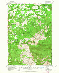
1955 Map of Colton
USGS Topo · Published 1963About this map
Highland and Colton anchor this mid-century portrait of Clackamas County, where the transition from agricultural valley to timbered highlands is clearly defined by a network of early roads and logging infrastructure. The map reveals the shift from older centers like Old Colton to the established Colton Sch and local milling operations. To the north, the Highland Millpond and Highland Sch mark a pocket of upland settlement, while the central landscape is dotted with small rural communities such as Elwood, Dodge, and Clarkes.
Find a feature on this map
64 named features on this map. Tap any name to fly to it.
Don’t see what you’re looking for? This feature index may not catch every label — zoom into the map to look around manually.
Map Details
Editions of this 1955 Colton Map
3 editions found

Other maps of this area

1911 · Boring
USGS Topo · 1:48,000

1914 · Boring
USGS Topo · 1:62,500

1914 · Oregon City
USGS Topo · 1:62,500

1916 · Estacada
USGS Topo · 1:125,000

1929 · Mill City
USGS Topo · 1:125,000

1939 · Molalla
USGS Topo · 1:62,500

1939 · Oregon City
USGS Topo · 1:62,500

1940 · Molalla
USGS Topo · 1:62,500

1940 · Boring
USGS Topo · 1:62,500

1941 · Oregon City
USGS Topo · 1:62,500