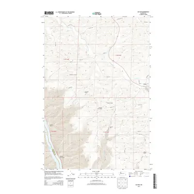
2013 Map of Colton
USGS Topo · Published 2013About this map
Colton serves as the primary hub on this Whitman County landscape, where the town site meets a network of local roads such as Depoe St and Steptoe St. The surrounding geography is defined by a series of deep, branching drainages that carve through the plateau, including Yakawawa Canyon, Schultheis Canyon, and the significant Steptoe Canyon. These landforms dictate the local movement and agricultural patterns, with Nesterbank Ranch situated among the high ground between the draws. In the southwest corner, the terrain drops towards the Snake River system at Lower Granite Lake, marked by the boundary between Whitman County and Garfield County. Waterways like Union Flat Cr and Steptoe Cr follow the canyon floors, illustrating the complex erosion patterns typical of the region. This 2013 survey provides a detailed look at the rural infrastructure and natural landmarks, from family-named routes like M Druffel Rd and J Meyer Rd to the distinct natural basins of Nisqually John Canyon.
Find a feature on this map
30 named features on this map. Tap any name to fly to it.
Don’t see what you’re looking for? This feature index may not catch every label — zoom into the map to look around manually.
Map Details
Editions of this 2013 Colton Map
This is the sole edition of this map. No revisions or reprints were ever made.
Other maps of this area

1910 · Pullman
USGS Topo · 1:125,000

1943 · Peola
USGS Topo · 1:62,500

1945 · Clarkston
USGS Topo · 1:62,500

1946 · Peola
USGS Topo · 1:62,500

1948 · Clarkston
USGS Topo · 1:62,500

1955 · Pullman
USGS Topo · 1:250,000

1958 · Pullman
USGS Topo · 1:250,000

1964 · Moscow West
USGS Topo · 1:24,000

1964 · Colton
USGS Topo · 1:24,000

1964 · Ewartsville
USGS Topo · 1:24,000