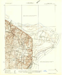
1935 Map of Columbia Bottom
USGS Topo · Published 1935About this map
Missouri River and Mississippi River currents meet at the northeastern tip of St. Louis County, defining a complex alluvial landscape just before the mid-century. The expansive Columbia Bottom dominates the eastern half of the sheet, a low-lying area crisscrossed by Ferry Road and Destrahan Road. Higher ground to the west reveals a dense network of rural infrastructure, including several family-named landmarks like the Vossenkemper School and Prigge School.
Find a feature on this map
44 named features on this map. Tap any name to fly to it.
Don’t see what you’re looking for? This feature index may not catch every label — zoom into the map to look around manually.
Map Details
Editions of this 1935 Columbia Bottom Map
This is the sole edition of this map. No revisions or reprints were ever made.
Other maps of this area

1888 · St. Louis
USGS Topo · 1:62,500

1927 · Alton
USGS Topo · 1:62,500

1927 · St. Charles
USGS Topo · 1:62,500
1933 · Granite City
USGS Topo · 1:24,000
1933 · Clayton
USGS Topo · 1:24,000
1933 · Saint Charles
USGS Topo · 1:62,500
1934 · Alton
USGS Topo · 1:62,500
1935 · Granite City
USGS Topo · 1:24,000

1935 · Florissant
USGS Topo · 1:24,000
1935 · Monks Mound
USGS Topo · 1:24,000