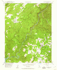
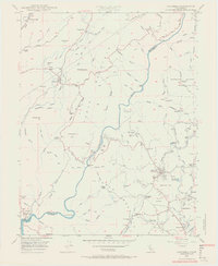
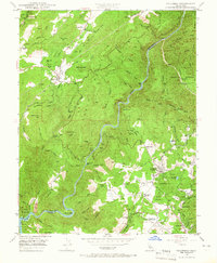
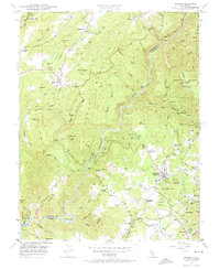
1948 Map of Columbia
USGS Topo · Published 1960About this map
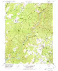
Columbia Historic State Park anchors this post-war survey of the California Mother Lode, capturing a landscape deeply shaped by gold-rush era extraction and later industrial quarrying. The complex topography around Table Mountain is etched with a network of historical infrastructure, from the flume and siphon systems to the winding Stanislaus River. Named settlements like Vallecito, Douglas Flat, and the curiously named Squabbletown reflect the dense habitation of the Sierra foothills before the mid-century. This map illustrates the transition from active mining at sites like the Dutchess Mine and Springfield Mine to a region focused on preservation and light industry, evidenced by the presence of the Columbia Airport Road and various Marble Quarries. Notable geological features such as the Natural Bridge and Moaning Caves highlight the area's subterranean limestone formations alongside its surface-level hydraulic history.
Find a feature on this map
112 named features on this map. Tap any name to fly to it.
Don’t see what you’re looking for? This feature index may not catch every label — zoom into the map to look around manually.
Map Details
Editions of this 1948 Columbia Map
5 editions found
Other maps of this area

1889 · Jackson
USGS Topo · 1:125,000

1891 · Big Trees
USGS Topo · 1:125,000

1892 · Jackson
USGS Topo · 1:125,000

1893 · Sonora
USGS Topo · 1:125,000

1894 · Big Trees
USGS Topo · 1:125,000

1896 · Sonora
USGS Topo · 1:125,000

1897 · Jackson
USGS Topo · 1:125,000

1897 · Sonora
USGS Topo · 1:125,000

1897 · Big Trees
USGS Topo · 1:125,000

1898 · Sonora
USGS Topo · 1:125,000