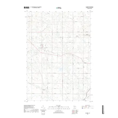
2018 Map of Columbia
USGS Topo · Published 2018About this map
The Columbia area of Clark County is defined by its complex web of waterways and rolling geography, particularly around the Neillsville Mounds in the northeast. This landscape is drained by a dense network of tributaries including Wedges Cr, Meadows Cr, and Helling Cr, which traverse a patchwork of rural roads like Co Rd G and Starr Rd. The small settlement of Sidney sits at a junction in the east, while the community of Columbia serves as a primary reference point in the south. For genealogists and local historians, the presence of the Columbia Cem and the North Pine Valley Cem provides specific points for mapping family history and early community footprints. The layout of the map reveals the persistence of rural township structures through the grid-like road system, such as W Maple Rd and Sidney Ave, which intersect the natural flow of Snyder Lake and various smaller creeks.
Find a feature on this map
50 named features on this map. Tap any name to fly to it.
Don’t see what you’re looking for? This feature index may not catch every label — zoom into the map to look around manually.
Map Details
Editions of this 2018 Columbia Map
This is the sole edition of this map. No revisions or reprints were ever made.
Other maps of this area

1924 · Black River Falls
USGS Topo · 1:62,500

1926 · Black River Falls
USGS Topo · 1:62,500

1948 · Fairchild
USGS Topo · 1:62,500

1949 · Fairchild
USGS Topo · 1:62,500

1953 · Neillsville
USGS Topo · 1:62,500

1953 · Eau Claire
USGS Topo · 1:250,000

1958 · Eau Claire
USGS Topo · 1:250,000

1958 · Hatfield
USGS Topo · 1:48,000

1964 · Eau Claire
USGS Topo · 1:250,000
1968 · Black River Falls
USGS Topo · 1:62,500