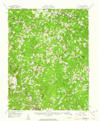
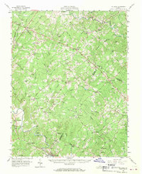
1960 Map of Columbia
USGS Topo · Published 1962About this map
The Rivanna River snakes through the southern reaches of this landscape, marking a historical corridor of transport and industry where the Chesapeake and Ohio railroad meets the water at Columbia. This intersection of rail and river supported local commerce at Rivanna Mills and Holmhead, while an extensive network of country roads connected inland settlements like Stage Junction and Kents Store. The map preserves the locations of numerous rural institutions, from the Columbia School to various neighborhood houses of worship including Zion Church and Byrd Chapel.
Find a feature on this map
98 named features on this map. Tap any name to fly to it.
Don’t see what you’re looking for? This feature index may not catch every label — zoom into the map to look around manually.
Map Details
Editions of this 1960 Columbia Map
2 editions found
Other maps of this area

1887 · Spottsylvania
USGS Topo · 1:125,000

1890 · Goochland
USGS Topo · 1:125,000

1891 · Palmyra
USGS Topo · 1:125,000

1892 · Spottsylvania
USGS Topo · 1:125,000

1892 · Goochland
USGS Topo · 1:125,000

1892 · Gordonsville
USGS Topo · 1:125,000

1895 · Palmyra
USGS Topo · 1:125,000

1897 · Palmyra
USGS Topo · 1:125,000

1935 · Charlottesville
USGS Topo · 1:62,500

1939 · Charlottesville
USGS Topo · 1:62,500