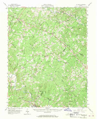
1960 Map of Columbia
USGS Topo · Published 1970About this map
Byrd Creek and the Rivanna River define the rural landscape of Fluvanna, Louisa, and Goochland counties at the dawn of the 1960s. This survey records the distribution of general stores and community centers that once served these agrarian communities, including Yanceys Store, Kents Store, and Butlers Store. The map captures a transition in transportation, showing the enduring path of Three Chop Road alongside modernizing crossings like Cosby Bridge.
Find a feature on this map
108 named features on this map. Tap any name to fly to it.
Don’t see what you’re looking for? This feature index may not catch every label — zoom into the map to look around manually.
Map Details
Editions of this 1960 Columbia Map
2 editions found

Other maps of this area

1887 · Spottsylvania
USGS Topo · 1:125,000

1890 · Goochland
USGS Topo · 1:125,000

1891 · Palmyra
USGS Topo · 1:125,000

1892 · Spottsylvania
USGS Topo · 1:125,000

1892 · Goochland
USGS Topo · 1:125,000

1892 · Gordonsville
USGS Topo · 1:125,000

1895 · Palmyra
USGS Topo · 1:125,000

1897 · Palmyra
USGS Topo · 1:125,000

1935 · Charlottesville
USGS Topo · 1:62,500

1939 · Charlottesville
USGS Topo · 1:62,500