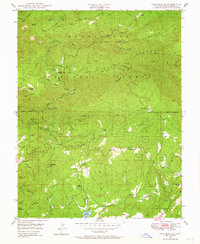
1948 Map of Columbia SE
USGS Topo · Published 1964About this map
Stanislaus National Forest serves as the backdrop for this late 1940s survey of Tuolumne County, where the legacy of California’s gold-seeking era is etched into the landscape through dozens of lode and placer claims. Mining operations like the Indian Girl Mine, Shanghai Mine, and Lucky Strike Mine follow the intricate network of ridges and gulches that feed into the Stanislaus River. The map documents a rugged transition from industrial extraction to mid-century rural settlement, featuring community hubs like Belleview Sch and the Phoenix Powerhouse near Phoenix Reservoir. Scattered throughout are sites that speak to the area’s diverse cultural history, from the Italian Ranch and Italian Bar to the French Camp (Site). These localized names, alongside family landmarks like Meentzen Gl and Blewetts Point, provide a window into the specific families and workers who populated these hills.
Find a feature on this map
59 named features on this map. Tap any name to fly to it.
Don’t see what you’re looking for? This feature index may not catch every label — zoom into the map to look around manually.
Map Details
Editions of this 1948 Columbia SE Map
4 editions found
Other maps of this area

1891 · Big Trees
USGS Topo · 1:125,000

1893 · Sonora
USGS Topo · 1:125,000

1894 · Big Trees
USGS Topo · 1:125,000

1896 · Sonora
USGS Topo · 1:125,000

1897 · Sonora
USGS Topo · 1:125,000

1897 · Big Trees
USGS Topo · 1:125,000

1898 · Sonora
USGS Topo · 1:125,000

1901 · Big Trees
USGS Topo · 1:125,000

1947 · Sacramento
USGS Topo · 1:250,000

1947 · San Jose
USGS Topo · 1:250,000