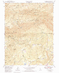
1948 Map of Columbia SE
USGS Topo · Published 1984About this map
The rugged Sierra Nevada foothills of Tuolumne County are defined here by a legacy of hydraulic mining and hydroelectric development. High on the ridges of the Stanislaus National Forest, numerous workings like the Indian Girl Mine, Noonday Mine, and Contention Mine trace the gold-bearing veins between Knight Ridge and the South Fork of the Stanislaus River. The landscape is interconnected by an intricate system of water conveyance, including the Tuolumne Main DITCH and Columbia DITCH, which diverted alpine flows for mining and power. Near the southern edge, the Phoenix Powerhouse and Phoenix Reservoir illustrate the early mid-century infrastructure supporting the region's utilities. Small settlements and specialized camps such as American Camp Station, French Camp (Site), and Old Oak Ranch are situated along winding roads and gulches, reflecting a pattern of habitation dictated by the steep terrain and the local timber and mineral economies.
Find a feature on this map
61 named features on this map. Tap any name to fly to it.
Don’t see what you’re looking for? This feature index may not catch every label — zoom into the map to look around manually.
Map Details
Editions of this 1948 Columbia SE Map
4 editions found
Other maps of this area

1891 · Big Trees
USGS Topo · 1:125,000

1893 · Sonora
USGS Topo · 1:125,000

1894 · Big Trees
USGS Topo · 1:125,000

1896 · Sonora
USGS Topo · 1:125,000

1897 · Sonora
USGS Topo · 1:125,000

1897 · Big Trees
USGS Topo · 1:125,000

1898 · Sonora
USGS Topo · 1:125,000

1901 · Big Trees
USGS Topo · 1:125,000

1947 · Sacramento
USGS Topo · 1:250,000

1947 · San Jose
USGS Topo · 1:250,000