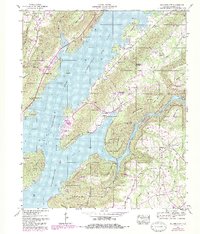
1947 Map of Columbus City
USGS Topo · Published 1985About this map
Guntersville Lake dominates this mid-century portrait of Marshall County, Alabama, where the rising waters of the Tennessee River reshaped the valley's geography. The map captures the significant land-use shift from traditional agriculture and milling at Campbell Mill to the recreation and conservation focus of Lake Guntersville State Park. High ridges such as Negro Mountain and Gunters Ridge provide a vertical contrast to the expansive water, while settlements like Meltonsville and Columbus City sit along the evolving shoreline. Genealogists will find a high density of burial grounds and rural pulpits, including Prospect Cem, Mt Moriah Church, and the distinctive Graveyard Hill (King Chapel Cem). This 1947 survey, later updated with photorevisions, reveals the early integration of infrastructure like the Substation and Filtration Plant into the Tennessee Valley Authority's broader management of the region.
Find a feature on this map
56 named features on this map. Tap any name to fly to it.
Don’t see what you’re looking for? This feature index may not catch every label — zoom into the map to look around manually.
Map Details
Editions of this 1947 Columbus City Map
3 editions found
Other maps of this area

1885 · Gadsden
USGS Topo · 1:125,000

1888 · Gadsden
USGS Topo · 1:125,000

1888 · Scottsboro
USGS Topo · 1:125,000

1892 · Scottsboro
USGS Topo · 1:125,000

1892 · Gadsden
USGS Topo · 1:125,000

1895 · Gadsden
USGS Topo · 1:125,000

1903 · Gadsden
USGS Topo · 1:125,000

1936 · Painter
USGS Topo · 1:24,000

1936 · Guntersville
USGS Topo · 1:24,000

1936 · Columbus City
USGS Topo · 1:24,000
Featured Places
- Guntersville, AL
- Star Point Subdivision, AL
- Five Points, AL
- Tanglewood, AL
- Little New York, Guntersville