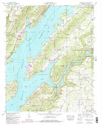
1947 Map of Columbus City
USGS Topo · Published 1985About this map
Guntersville Lake dominates this mid-century landscape, a flooded valley where the Tennessee River meets steep ridges. The 1947 topography, later updated with purple woodland revisions, shows the intricate shoreline of the reservoir around Columbus City and Meltonsville. This area reflects the profound changes brought by the Tennessee Valley Authority, with former lowlands submerged and new boundaries established for Lake Guntersville State Park.
Find a feature on this map
51 named features on this map. Tap any name to fly to it.
Don’t see what you’re looking for? This feature index may not catch every label — zoom into the map to look around manually.
Map Details
Editions of this 1947 Columbus City Map
3 editions found
Other maps of this area

1885 · Gadsden
USGS Topo · 1:125,000

1888 · Gadsden
USGS Topo · 1:125,000

1888 · Scottsboro
USGS Topo · 1:125,000

1892 · Scottsboro
USGS Topo · 1:125,000

1892 · Gadsden
USGS Topo · 1:125,000

1895 · Gadsden
USGS Topo · 1:125,000

1903 · Gadsden
USGS Topo · 1:125,000

1936 · Painter
USGS Topo · 1:24,000

1936 · Guntersville
USGS Topo · 1:24,000

1936 · Columbus City
USGS Topo · 1:24,000
Featured Places
- Guntersville, AL
- Star Point Subdivision, AL
- Five Points, AL
- Tanglewood, AL
- Little New York, Guntersville