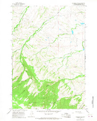
1964 Map of Columbus Peak
USGS Topo · Published 1968About this map
Bighorn National Forest dominates the southern landscape of this mid-1960s survey, rising sharply toward the prominent summit of Columbus Peak. The terrain is defined by a series of steep drainages, including the headwaters of West Pass Creek and East Pass Creek. These canyons provided natural corridors for early movement, evidenced by the presence of a Pack Trail and a Stock Driveway winding through the forest.
Find a feature on this map
26 named features on this map. Tap any name to fly to it.
Don’t see what you’re looking for? This feature index may not catch every label — zoom into the map to look around manually.
Map Details
Editions of this 1964 Columbus Peak Map
This is the sole edition of this map. No revisions or reprints were ever made.
Other maps of this area

1894 · Rosebud
USGS Topo · 1:125,000

1894 · St. Xavier
USGS Topo · 1:125,000

1895 · Dayton
USGS Topo · 1:125,000

1898 · Bald Mountain
USGS Topo · 1:125,000

1901 · Rosebud
USGS Topo · 1:125,000

1901 · Dayton
USGS Topo · 1:125,000

1901 · St. Xavier
USGS Topo · 1:125,000

1901 · Bald Mountain
USGS Topo · 1:125,000

1954 · Hardin
USGS Topo · 1:250,000

1955 · Sheridan
USGS Topo · 1:250,000