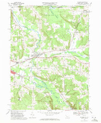
1968 Map of Columbus
USGS Topo · Published 1971About this map
Brokenstraw Creek and its many tributaries, including Coffee Creek and Cold Spring Brook, dominate the landscape of northwestern Warren County in this late 1960s snapshot. The industrial and transportation corridor follows the valley floors, where the Penn Central and Erie-Lackawanna railroads intersect at Columbus. This rail network supported local commerce and connected smaller settlements like Spring Creek and Colza to larger markets.
Find a feature on this map
48 named features on this map. Tap any name to fly to it.
Don’t see what you’re looking for? This feature index may not catch every label — zoom into the map to look around manually.
Map Details
Editions of this 1968 Columbus Map
4 editions found
Other maps of this area

1904 · Chautaqua
USGS Topo · 1:62,500

1905 · Clymer
USGS Topo · 1:62,500

1926 · Youngsville
USGS Topo · 1:62,500

1929 · Corry
USGS Topo · 1:48,000

1929 · Youngsville
USGS Topo · 1:62,500

1932 · Corry
USGS Topo · 1:62,500

1939 · Clymer
USGS Topo · 1:62,500

1941 · Chautauqua
USGS Topo · 1:62,500

1941 · Clymer
USGS Topo · 1:62,500

1943 · Youngsville
USGS Topo · 1:62,500