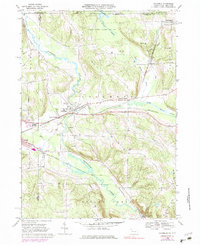
1968 Map of Columbus
USGS Topo · Published 1983About this map
Brokenstraw Creek meanders through this landscape, which straddles the border between Pennsylvania and New York. The valley floor is defined by a dense intersection of transport and industry, where the Penn Central and Erie-Lackawanna railroads follow the natural drainage of the land. Small clusters of settlement like Columbus and Scotts Crossing serve as nodes along these transit corridors, while the presence of several Gas Wells and Oil Wells further south indicates the regional reliance on resource extraction during the late 1960s.
Find a feature on this map
45 named features on this map. Tap any name to fly to it.
Don’t see what you’re looking for? This feature index may not catch every label — zoom into the map to look around manually.
Map Details
Editions of this 1968 Columbus Map
4 editions found
Other maps of this area

1904 · Chautaqua
USGS Topo · 1:62,500

1905 · Clymer
USGS Topo · 1:62,500

1926 · Youngsville
USGS Topo · 1:62,500

1929 · Corry
USGS Topo · 1:48,000

1929 · Youngsville
USGS Topo · 1:62,500

1932 · Corry
USGS Topo · 1:62,500

1939 · Clymer
USGS Topo · 1:62,500

1941 · Chautauqua
USGS Topo · 1:62,500

1941 · Clymer
USGS Topo · 1:62,500

1943 · Youngsville
USGS Topo · 1:62,500