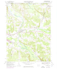
1968 Map of Columbus
USGS Topo · Published 1975About this map
Brokenstraw Creek and Hare Creek define the drainage patterns of this corner of Warren County, where the valley floors are marked by significant wetlands like Tamarack Swamp and Benson Swamp. The landscape is a mix of agricultural uplands and concentrated transportation corridors, with the Penn Central and Erie-Lackawanna railroads both cutting through the territory. These rail lines served as the backbone for settlements such as Columbus, Bear Lake, and the small industrial hub at Colza.
Find a feature on this map
49 named features on this map. Tap any name to fly to it.
Don’t see what you’re looking for? This feature index may not catch every label — zoom into the map to look around manually.
Map Details
Editions of this 1968 Columbus Map
4 editions found
Other maps of this area

1904 · Chautaqua
USGS Topo · 1:62,500

1905 · Clymer
USGS Topo · 1:62,500

1926 · Youngsville
USGS Topo · 1:62,500

1929 · Corry
USGS Topo · 1:48,000

1929 · Youngsville
USGS Topo · 1:62,500

1932 · Corry
USGS Topo · 1:62,500

1939 · Clymer
USGS Topo · 1:62,500

1941 · Chautauqua
USGS Topo · 1:62,500

1941 · Clymer
USGS Topo · 1:62,500

1943 · Youngsville
USGS Topo · 1:62,500