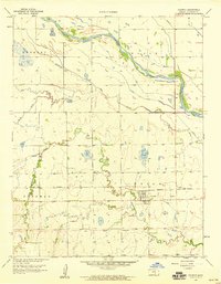
1958 Map of Colwich
USGS Topo · Published 1959About this map
Colwich serves as the central hub of this late-1950s Kansas landscape, situated where the Missouri Pacific railroad cuts through the agricultural plains of Union and Sherman townships. The map documents a complex hydraulic environment, dominated by the wide path of the Arkansas River and its accompanying system of levees, which regulate flow through the northern reaches. South of the river, the winding paths of Big Slough and Cowskin Creek reveal a lowland terrain shaped by natural drainage and an artificial Aqueduct. Of particular interest to local historians is the Old Indian Boundary line running east-to-west across the lower third of the quadrangle, preserving a record of earlier territorial partitions amidst the mid-century infrastructure of TV Towers and municipal Sewage Disposal sites.
Find a feature on this map
15 named features on this map. Tap any name to fly to it.
Don’t see what you’re looking for? This feature index may not catch every label — zoom into the map to look around manually.
Map Details
Editions of this 1958 Colwich Map
2 editions found
Other maps of this area

1889 · Cheney
USGS Topo · 1:125,000

1889 · Wichita
USGS Topo · 1:125,000

1891 · Cheney
USGS Topo · 1:125,000

1894 · Wichita
USGS Topo · 1:125,000

1901 · Cheney
USGS Topo · 1:125,000

1941 · Maize
USGS Topo · 1:31,680

1942 · Maize
USGS Topo · 1:31,680

1943 · Wichita West
USGS Topo · 1:31,680

1955 · Wichita
USGS Topo · 1:250,000
1956 · Maize
USGS Topo · 1:24,000