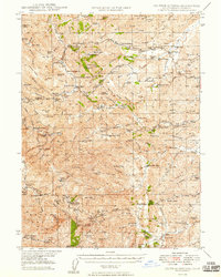
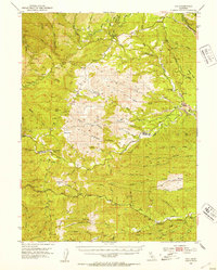
1949 Map of Colyear Springs
USGS Topo · Published 1949About this map
Ellison Saunders Ranch and dozens of other family homesteads define the mid-century ranching landscape of the Tehama County foothills. The map reveals a highly decentralized pattern of settlement where life centered on named flats and remote cabins, such as the Halley Cabin and Pete Hoff Place. This region is defined by the complex drainage of Redbank Creek and various forks of Cold Fork Cottonwood Creek, where water was the primary driver for both agriculture and industry.
Find a feature on this map
115 named features on this map. Tap any name to fly to it.
Don’t see what you’re looking for? This feature index may not catch every label — zoom into the map to look around manually.
Map Details
Editions of this 1949 Colyear Springs Map
This is the sole edition of this map. No revisions or reprints were ever made.
Other maps of this area

1890 · Red Bluff
USGS Topo · 1:250,000

1894 · Red Bluff
USGS Topo · 1:250,000
1944 · Flournoy
USGS Topo · 1:62,500
1947 · Anderson
USGS Topo · 1:62,500
1948 · Anderson
USGS Topo · 1:62,500
1951 · Chanchelulla Peak
USGS Topo · 1:62,500
1952 · Blossom
USGS Topo · 1:24,000
1952 · Red Bank
USGS Topo · 1:24,000
1952 · Paskenta
USGS Topo · 1:62,500
1952 · Ono
USGS Topo · 1:62,500