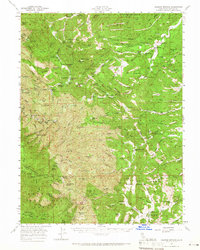
1957 Map of Colyear Springs
USGS Topo · Published 1966About this map
The eastern edges of the Mendocino National Forest and Trinity Nat Forest meet in this mid-century survey of western Tehama County. The landscape is defined by the complex drainage of the Middle Fork Cottonwood Creek and its many tributaries, where the topography transitions from high peaks like Salt Creek Peak down toward the Sacramento Valley foothills. The map reveals a land once heavily utilized by homesteaders and ranchers, evidenced by dozens of named small-scale clearings and family sites including Widow Wilson Flat, the Burrill Homestead, and the Pettyjohn Place.
Find a feature on this map
147 named features on this map. Tap any name to fly to it.
Don’t see what you’re looking for? This feature index may not catch every label — zoom into the map to look around manually.
Map Details
Editions of this 1957 Colyear Springs Map
2 editions found

Other maps of this area

1890 · Red Bluff
USGS Topo · 1:250,000

1894 · Red Bluff
USGS Topo · 1:250,000

1944 · Flournoy
USGS Topo · 1:62,500

1947 · Anderson
USGS Topo · 1:62,500

1948 · Anderson
USGS Topo · 1:62,500

1949 · Colyear Springs
USGS Topo · 1:62,500

1951 · Chanchelulla Peak
USGS Topo · 1:62,500

1952 · Blossom
USGS Topo · 1:24,000

1952 · Red Bank
USGS Topo · 1:24,000

1952 · Paskenta
USGS Topo · 1:62,500