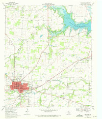
1969 Map of Comanche
USGS Topo · Published 1972About this map
Comanche serves as the hub of this Central Texas landscape, organized around its central Courthouse and a grid of streets including Central Ave and Houston St. The town's mid-century infrastructure is well-documented, from the Comanche Airport and Memorial Stadium to the Sewage Disposal Ponds and the regional Hospital. Beyond the town limits, the Atchison Topeka and Santa Fe railroad tracks cut a diagonal path across the countryside, connecting the main settlement to outlying points like Gartman View.
Find a feature on this map
48 named features on this map. Tap any name to fly to it.
Don’t see what you’re looking for? This feature index may not catch every label — zoom into the map to look around manually.
Map Details
Editions of this 1969 Comanche Map
This is the sole edition of this map. No revisions or reprints were ever made.
Other maps of this area

1888 · Hamilton
USGS Topo · 1:125,000

1889 · Brownwood
USGS Topo · 1:125,000

1890 · Stephenville
USGS Topo · 1:125,000

1894 · Hamilton
USGS Topo · 1:125,000

1894 · Eastland
USGS Topo · 1:125,000

1894 · Brownwood
USGS Topo · 1:125,000

1920 · Stephenville
USGS Topo · 1:125,000

1954 · Brownwood
USGS Topo · 1:250,000

1954 · Abilene
USGS Topo · 1:250,000

1956 · Gustine
USGS Topo · 1:62,500