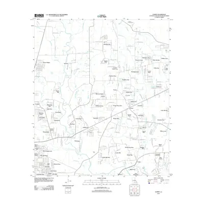
2012 Map of Comite
USGS Topo · Published 2012About this map
The Comite River and its dense network of tributaries, including White Bayou, Blackwater Bayou, and Beaver Bayou, define the landscape of this East Baton Rouge Parish region. By the early 21st century, the area shows a distinct transition from riparian woodlands to established residential communities. Longstanding family and local heritage is preserved in sites such as Lovett Cem, Odom Cem, and Edwards Cem, which sit alongside mid-century and modern developments like Brown Heights, Welcome Heights, and Pinewood Acres. The map also captures specialized land uses, from the youth-oriented Camp Yola Kahn near Plantation Way to the Flying J Ranch Airport in the north. This survey documents the suburban expansion of the Baton Rouge outskirts, where small landing strips and historic cemeteries remain interspersed among burgeoning neighborhoods like Sherrington Place and Crystal Place.
Find a feature on this map
165 named features on this map. Tap any name to fly to it.
Don’t see what you’re looking for? This feature index may not catch every label — zoom into the map to look around manually.
Map Details
Editions of this 2012 Comite Map
This is the sole edition of this map. No revisions or reprints were ever made.
Other maps of this area

1906 · Bayou Sara
USGS Topo · 1:125,000

1908 · Baton Rouge
USGS Topo · 1:62,500

1934 · Denham Springs
USGS Topo · 1:62,500

1939 · Zachary
USGS Topo · 1:62,500

1939 · Denham Springs
USGS Topo · 1:62,500

1939 · Baton Rouge
USGS Topo · 1:62,500

1942 · Pride
USGS Topo · 1:31,680

1942 · Watson
USGS Topo · 1:31,680

1953 · Baton Rouge West
USGS Topo · 1:24,000
1953 · Baton Rouge East
USGS Topo · 1:24,000