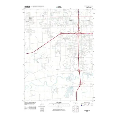
2010 Map of Commerce
USGS Topo · Published 2010About this map
The Raccoon River winds through the southern landscape of this 2010 survey, anchoring a region undergoing significant suburban transformation. Small, established communities like Commerce and Ashawa sit adjacent to modern residential developments and sprawling infrastructure. The mapping detail highlights a transition from older landmarks, such as the Huston Cemetery and the Dale Moffit Reservoir Cemetery, to contemporary recreational and utility sites. To the south, the Dale Maffit Reservoir serves as a major water feature, while further north, Sugar Creek Lake is contained by the Sugar Creek Lake Dam. The suburban expansion of Waukee is evident in the northwestern corner with the plotting of Midwest Country Estates. This map documents a moment when traditional rural settlements were being integrated into the larger metropolitan footprint, connected by thoroughfares such as Booneville Rd and Grand Ave.
Find a feature on this map
42 named features on this map. Tap any name to fly to it.
Don’t see what you’re looking for? This feature index may not catch every label — zoom into the map to look around manually.
Map Details
Editions of this 2010 Commerce Map
This is the sole edition of this map. No revisions or reprints were ever made.
Other maps of this area

1905 · Des Moines
USGS Topo · 1:62,500

1907 · Des Moines
USGS Topo · 1:62,500

1908 · Waukee
USGS Topo · 1:62,500

1931 · Indianola
USGS Topo · 1:62,500

1951 · St. Charles
USGS Topo · 1:62,500

1954 · Des Moines
USGS Topo · 1:250,000

1956 · Des Moines
USGS Topo · 1:250,000

1956 · Des Moines NW
USGS Topo · 1:24,000

1956 · Des Moines SW
USGS Topo · 1:24,000

1956 · Des Moines
USGS Topo · 1:62,500