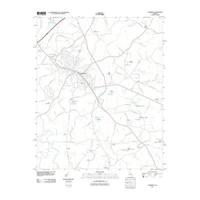
2011 Map of Commerce
USGS Topo · Published 2011About this map
Commerce serves as the hub of this North Georgia landscape, where modern transportation corridors like the Steve Reynolds Industrial Pkwy meet historic family-named routes and rural cemeteries. The area is defined by a complex drainage network featuring the North Oconee River and numerous tributaries such as Beaverdam Creek and Turkey Creek. Many of these waterways have been managed through civil engineering, resulting in features like Marlow Lake and several numbered reservoirs, including Reservoir 18 and Reservoir 23. This 2011 survey documents a mix of agricultural heritage and industrial growth, preserving the location of long-established community sites like Five Points alongside newer developments. Genealogists will find a wealth of data in the many burial grounds scattered across the quadrangle, from Gray Hill Cemetery near the town center to more remote sites like Howington Cemetery and Harris-Lord Cemetery.
Find a feature on this map
106 named features on this map. Tap any name to fly to it.
Don’t see what you’re looking for? This feature index may not catch every label — zoom into the map to look around manually.
Map Details
Editions of this 2011 Commerce Map
This is the sole edition of this map. No revisions or reprints were ever made.
Other maps of this area

1891 · Gainesville
USGS Topo · 1:125,000

1891 · Carnesville
USGS Topo · 1:125,000

1954 · Greenville
USGS Topo · 1:250,000

1958 · Greenville
USGS Topo · 1:250,000

1964 · Commerce
USGS Topo · 1:24,000

1964 · Maysville
USGS Topo · 1:24,000

1964 · Ila
USGS Topo · 1:24,000

1964 · Ashland
USGS Topo · 1:24,000
1964 · Nicholson
USGS Topo · 1:24,000

1964 · Hull
USGS Topo · 1:24,000