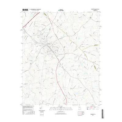
2017 Map of Commerce
USGS Topo · Published 2017About this map
Commerce serves as a central hub in this Jackson County landscape, where the convergence of major corridors like the Steve Reynolds Industrial Pkwy and Homer Rd reflects modern commercial development alongside deep-rooted community foundations. The map reveals an area defined by its water and ancestry, from the winding path of the North Oconee River and Turkey Cr to the numerous family and church burial grounds that dot the rural outskirts. Genealogists will find a wealth of specific locations including Harmony Cem, Mount Bethel Cem, and Cabin Creek Cem. The transition from the urban grid of Commerce to the outlying community of Five Points highlights a pattern of growth that follows traditional ridge lines and creek valleys, while public spaces like Jackson Memorial Park and Doug Bolton Field mark the local social geography.
Find a feature on this map
184 named features on this map. Tap any name to fly to it.
Don’t see what you’re looking for? This feature index may not catch every label — zoom into the map to look around manually.
Map Details
Editions of this 2017 Commerce Map
This is the sole edition of this map. No revisions or reprints were ever made.
Other maps of this area

1891 · Gainesville
USGS Topo · 1:125,000

1891 · Carnesville
USGS Topo · 1:125,000

1954 · Greenville
USGS Topo · 1:250,000

1958 · Greenville
USGS Topo · 1:250,000

1964 · Commerce
USGS Topo · 1:24,000

1964 · Maysville
USGS Topo · 1:24,000

1964 · Ila
USGS Topo · 1:24,000

1964 · Ashland
USGS Topo · 1:24,000
1964 · Nicholson
USGS Topo · 1:24,000

1964 · Hull
USGS Topo · 1:24,000