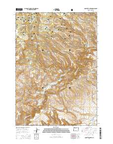
2014 Map of Committee Creek
USGS Topo · Published 2014About this map
Ochoco National Forest dominates this high-desert landscape in central Oregon, where a complex network of seasonal water sources and canyons defines the topography. The North Fork Crooked River and its tributaries, including Committee Creek and Swamp Creek, carve through the high country between Funeral Ridge and Long Ridge. This 2014 survey documents a land managed for water retention and livestock, characterized by numerous small-scale water projects such as Lutsey Reservoir, Mudhole Reservoir, and the evocatively named Hole-in-the-Ground Reservoir. Historically significant springs, such as Telephone Springs and Committee Spring, dot the terrain, while landmarks like Battle Point and Oscar Canyon provide orientation across the remote acreage. The map also traces the winding path of Rough Canyon Road and SE Teaters, providing a record of access through these rugged canyons and prairies.
Find a feature on this map
48 named features on this map. Tap any name to fly to it.
Don’t see what you’re looking for? This feature index may not catch every label — zoom into the map to look around manually.
Map Details
Editions of this 2014 Committee Creek Map
This is the sole edition of this map. No revisions or reprints were ever made.
Other maps of this area

1951 · Post
USGS Topo · 1:62,500

1951 · Lookout Mtn
USGS Topo · 1:62,500

1955 · Bend
USGS Topo · 1:250,000

1957 · Bend
USGS Topo · 1:250,000

1958 · Bend
USGS Topo · 1:250,000

1965 · Williams Prairie
USGS Topo · 1:24,000

1966 · Keys Creek
USGS Topo · 1:24,000

1981 · Prineville
USGS Topo · 1:100,000

1982 · Arrowwood Point
USGS Topo · 1:24,000
1982 · Rabbit Valley
USGS Topo · 1:24,000