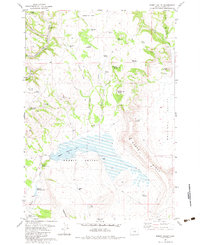
1982 Map of Rabbit Valley
USGS Topo · Published 1983About this map
The Crooked River cuts through the northwest corner of this Crook County landscape, defining a terrain dominated by livestock water management and high-desert elevations. In the early 1980s, this area of Rabbit Valley and Paulina Valley was heavily shaped by a network of small reservoirs and springs essential for ranching, including the series of Merwin Reservoir No 3, Merwin Reservoir No 2, and Merwin Reservoir No 1.
Find a feature on this map
46 named features on this map. Tap any name to fly to it.
Don’t see what you’re looking for? This feature index may not catch every label — zoom into the map to look around manually.
Map Details
Editions of this 1982 Rabbit Valley Map
This is the sole edition of this map. No revisions or reprints were ever made.
Other maps of this area

1932 · Dayville
USGS Topo · 1:125,000

1936 · Dayville
USGS Topo · 1:125,000

1955 · Bend
USGS Topo · 1:250,000

1955 · Canyon City
USGS Topo · 1:250,000

1957 · Bend
USGS Topo · 1:250,000

1958 · Bend
USGS Topo · 1:250,000

1959 · Canyon City
USGS Topo · 1:250,000

1965 · Williams Prairie
USGS Topo · 1:24,000

1966 · Keys Creek
USGS Topo · 1:24,000

1966 · Little Summit Prairie
USGS Topo · 1:24,000