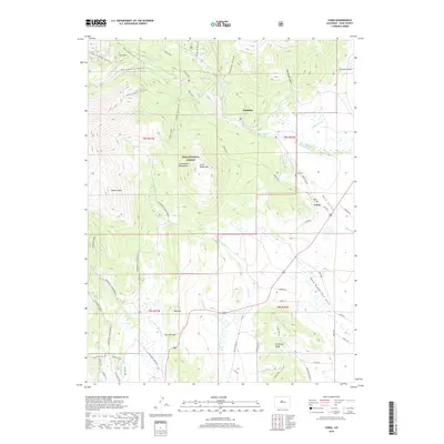
2019 Map of Como
USGS Topo · Published 2019About this map
Como serves as a focal point in this high-altitude landscape of Park County, where the historic settlement is situated near the Como Cem and Como Lake. The surrounding terrain of the Pike National Forest is defined by a complex network of water rights and drainage, evidenced by the Fremont Ditch, Slater Ditch, and O'Neil Ditch that lace the meadows east of the mountains. Transportation routes through the area are varied, ranging from the well-traveled Boreas Pass Rd to the recreational Silverheels Snowmobile trails.
Find a feature on this map
64 named features on this map. Tap any name to fly to it.
Don’t see what you’re looking for? This feature index may not catch every label — zoom into the map to look around manually.
Map Details
Editions of this 2019 Como Map
This is the sole edition of this map. No revisions or reprints were ever made.
Other maps of this area

1889 · Leadville
USGS Topo · 1:125,000

1891 · Leadville
USGS Topo · 1:125,000

1934 · Climax
USGS Topo · 1:48,000

1937 · Como
USGS Topo · 1:62,500

1938 · Mt. Lincoln
USGS Topo · 1:48,000

1942 · Leadville
USGS Topo · 1:125,000

1945 · Mount Lincoln
USGS Topo · 1:62,500

1953 · Denver
USGS Topo · 1:250,000

1956 · Elkhorn
USGS Topo · 1:24,000

1956 · Fairplay East
USGS Topo · 1:24,000